Analysis of Accident Sites from Motorcycles among High School
Students Using Geographic Information Systems, Sukhothai Province
Thipthimwong, K.* and Noosorn, N.
Faculty of Public Health, Naresuan University, Phitsanulok, Thailand
E-mail:
ketkarn_tip@hotmail.com,
narongsak@nu.ac.th
*Corresponding Author
Abstract
Road accidents are a major global problem, especially accidents from
riding a motorcycle, as these affect both human life and
property.Therefore, identifying accident sites is
important for accident prevention. This study aimed
to analyze the density of accident sites involving motorcycles among
high school students in 2019 by using Geographic Information System
data (GIS) in Sukhothai
Province. In the study, in-depth
interviews were used with respondents, including high school
students who had accidents on motorcycles, and traffic police
officers who were responsible for investigating accidents in
schools. In addition, reports of accident sites were
used to arrange GIS data layers and analyze the density of the
accident sites using Kernel Density Estimation
(KDE). The study results revealed
that accidents occurred at 217 accident sites in the study
area. The map of accident sites and density was
created by using GIS data. The areas with accidents
in heavy traffic were the roads in the three main districts: Mueang,
Si Samrong, and Sawankhalok. Regarding the analysis,
accidents were caused by fast cut-off riding,
narrow road shoulders, and road users’ non-compliance
with traffic regulations. The study results were
submitted to traffic authorities, schools, departments responsible
for rural roads, and local government organizations, and used for
planning and developing models to prevent traffic accidents
involving motorcycles among high school students through the
student council.
Keywords: Accident Sites, Geographical Information System, High School,
Kernel Density Estimation, Motorcycles
1. Background and Statement of Problems
The average death rate from road accidents worldwide is 155 cases/hour
or 3,700 cases/day, whereas the injury rate is 136,987 cases/day and
3/4 of these are males. It is also found that the injury and death
rates are increasing in developing countries, and more than half of the
death cases involved motorcyclists (23%), pedestrians (22%), and
cyclists (4%)[1].
According to the 2020 estimation of the Road Safety Center in Thailand,
Thai people died from traffic accidents at an average rate of 2.5
cases/hour, 60 cases/day, or 22,281 cases/year while the injuries arose
at an average rate of 107,542 cases/year. Such rates were ranked
highest among ASEAN countries and in 9th position in the world, with
the death rate of 36.2 cases/100,000 population
[2].
Based on the death certificates, traffic accidents are the leading
cause of death among children aged 10 – 14 years
[3].
In 2019, the death rate of Thai youths from crashes on the roads was
42.6 cases/100,000 population, considered as the highest rate in the
world. The group with the highest number of deaths was aged 15 – 18
years; i.e., the high school age. Every day, 13 teenagers died on
average, while 800 were injured, 50 severely, and 7 became disabled.
Accordingly, 4/5 of the deaths were males
[4].
Such losses were ranked second in terms of years of life lost due to
death or disability. World Health Organization [5]
According to the investigation results, motorcycles are the vehicles
which are most relevant to accidents at 40 – 70%
[6].
Sukhothai is a province with highly ranked statistics of traffic
accidents in Health Region 2, and shows an increasing trend. Based on
the statistics in 2016 – 2018, the injury rates from traffic accidents
were 684.45, 734.2 and 798.31 per 100,000 population, respectively
[7].
In the case of high school students, the injury rate was high at
414.34, 459.31, and 487.32 per 100,000 population, respectively, whereas
the death rate was 5.6, 8.3, and 10.5 per 100,000 population,
respectively. The vehicles most commonly involved in traffic accidents
were motorcycles (81.3) during the accident period of 3 pm – 11 pm
[8].
Traffic accidents involving motorcycles were mostly found in school
aged riders which is an important age for the national future.
Therefore, the researchers were interested to study factors affecting
traffic accidents involving motorcycles among high school students in
Sukhothai Province in order to create models for preventing death and
injury from road accidents.
Geographic Information System (GIS) is an instrument and a database
used for recording, editing, improving, analyzing, displaying, and
reporting spatial data through a computer. GIS is also a connector of
relationships among various data so it is used for managing, planning,
and solving different problems. GIS is considered as technology
distinctive in analyzing and presenting spatial data, especially in the
form of maps, so it is widely applied. In this study, GIS was used to
create a database for analyzing accident sites. GIS has popularly been
used in many studies since it is a high-performance computer system for
storing, editing, and analyzing spatial data. Moreover, GIS outcomes are
reliable since the system is controlled by data, conditions, and
criteria. The GIS analysis can be used to develop a database of traffic
accidents and dangerous/risk sites of traffic accidents, and the
severity index (S) is used to classify risk levels of dangerous sites,
numbers of traffic accidents, numbers of dead, numbers of seriously
injured, numbers of injured, and roads and surrounding factors which
include road types, road surfaces, lane widths, lighting, and land use.
It is considered that the examples of analyzing dangerous sites with
GIS can lead to guidelines for preventing and reducing traffic
accidents in the area.
This research arranged a GIS database to support the management of
traffic accidents involving motorcycles among high school students in 9
districts of Sukhothai Province in the areas where the traffic was the
heaviest in Sukhothai in order to analyze the density of traffic
accidents for risk assessment in those areas. The study results can lead
to identification of the risk points, and then to warn, provide
surveillance, manage solutions, and carry out risk reduction at those
risk points.
2. Research Question and Objectives
This study is focused to determine how a GIS base system can be used
for recording, correcting, improving, analyzing, displaying, and
reporting accident data in Sukhothai Province. The Objectives of the
study are 1.) To create a GIS database of accident sites involving
motorcycles among high school students in Sukhothai Province, and 2.)
to analyze the density of traffic accidents involving motorcycles among
high school students by using the Geographic Information System in
Sukhothai Province
3. Methods
This qualitative research was implemented to study geographical
situations with effects on traffic accidents involving motorcycles
among high school students. This study was a part of an advanced
mixed-methods research design with multistage evaluation design in the
project of Model for Preventing Traffic Accidents Among High School
Students Through the Student Council in Sukhothai Province. The study
was approved in terms of its research ethics by the Human Research
Ethics Committee, Naresuan University, with the project code IRB No.
P2-0158/2565 and the research project approval COA No. 307/2022.
3.1 Population and Samples
-The respondents were divided into 2 groups selected with
criterion sampling as follows. Group 1 Motorcyclists who were high
school students in Sukhothai Province, had a history of having
motorcycle accidents in 2019, and lived in Sukhothai Province. The
number of these motorcyclists was 16, or until the data were saturated.
-And group 2 Traffic police officers who worked in
Sukhothai Province, and were responsible for managing and reporting
traffic accidents. The number of these traffic police officers was 9,
or until the data were saturated. The
in-depth interview was applied to acquire the in-depth data, which
reveals the traffic accident situation, so the preventive plan can be
set inclusively.
3.2 Research Instruments
In-depth interviews and the following instruments (Table 1).
Table 1: Research instrument for rolls and duties
|
No.
|
Types of Instruments
|
Roles/Duties
|
|
1.
|
Data layer of the study area boundaries, i.e., a
GIS spatial data layer in shape files with the scale of
1: 50,000, developed by the Royal Thai Survey
Department, Ministry of Defense
|
Use for determining physical geographical scale.
|
|
2.
|
Data layer of transportation routes, developed by the
Department of Public Works and Town & Country
Planning, Ministry of Interior
|
Use for identifying administrative districts.
|
|
3.
|
Data of traffic accidents in 2019, from Traffic
Works, Sukhothai Provincial Police Station [9].
|
Use for managing lawsuits.
|
|
4.
|
Data of traffic accidents in 2019, from
Non-communicable Disease Affairs, Sukhothai
Provincial Health Office [10].
|
Use for supervising and preventing accidents.
|
|
5.
|
Survey about traffic accidents: Camera Tools and
Equipment Used in the Study
|
Use for taking photos at accident sites
|
|
6.
|
Computer set and operating system
|
Use for recording data.
|
|
7.
|
Spreadsheet program
|
Use for processing data.
|
3.3 Research Procedure
1. Collect the data of traffic accidents in 2019 from Non-communicable
Disease Affairs, Sukhothai Provincial Health Office. The data were in
the form of an IS on line files which included main data such as
accident sites (IS online is the data system/injury monitoring report
to use with the program. IS Online can connect with the online database
of hospitals across Thailand), photos of accidents, vehicle types in
accidents, and number of injured and dead people. The data were from
all hospitals in the 2019. [10], and were screened to select only the
cases of accidents involving motorcycles, encoded ICD 10 V20 – V29,
occurring with high school students at the age of 15 – 18 years who
were selected for the in-depth interviews.
2. Download the KML files through the website of Traffic Works,
Sukhothai Provincial Police Station, which was responsible for
supervising and managing all traffic works in Sukhothai Province. The
files included main data such as accident sites, photos of accidents,
vehicle types in accidents, and the number of injured and dead people.
3. Arrange the data into the MIS (management information system) files
by using the spreadsheet program.
4. Perform the fieldwork survey at the actual sites of traffic
accidents. Record the data in a survey record. The purpose was to
survey additional aspects of traffic accidents. Then, take photos and
collect the data of location coordinates through the GPS device.
5. Put the coordinate data (East: X, and North: Y) collected from the
survey in association with the data of each site in the spreadsheet program, as shown in
Figure 1
.
6. Import the survey data and coordinate values through the GIS
program. Create the GIS data layer of the accident sites in point shape
files and the GIS data dictionary.
7. Import basic data including area boundaries, main roads, and
secondary roads. Then, create maps of accident sites.
8. Estimate the spatial density of the accident sites by using Kernel
Density Estimation (KDE) to analyze the areas from the center and
Network Kernel Density Estimation (NKDE) to analyze the area networks.
9. Classify the density of traffic accidents into 3 levels: high,
moderate, and low. Create maps of traffic accident density in the
areas.
10. Record, synthesize, and conclude the study results.
In the analysis, the step of accident information from motorcycle in Sukhothai was performed by collecting, screening, and selecting only data of
motorcycle accidents. The data were encoded ICD 10 V20 – V29. The
in-depth interview and the on-site survey were performed in the actual
accident sites. In the step of modify GIS layer, the survey
data and coordinate values were imported to create the internal
dot-shape files and data dictionary through the GIS program. The
spatial analysis
was performed by surveying and taking photos in the actual accident
sites whereas the behavioral analysis was conducted with the
in-depth interview in all cases. The spatial density of accidents was
assessed at the accident sites by using Kernel Density Estimation (KDE)
to classify density of road accidents. The step of
reflect back information
was implemented by returning data to Road Safety Center, Traffic Police
offices, and Sukhothai Basic Education Office.
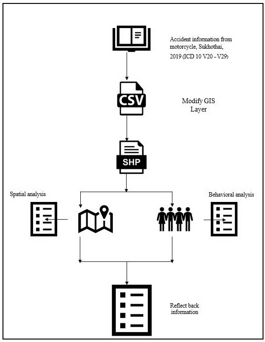
Figure 1: Flow chart
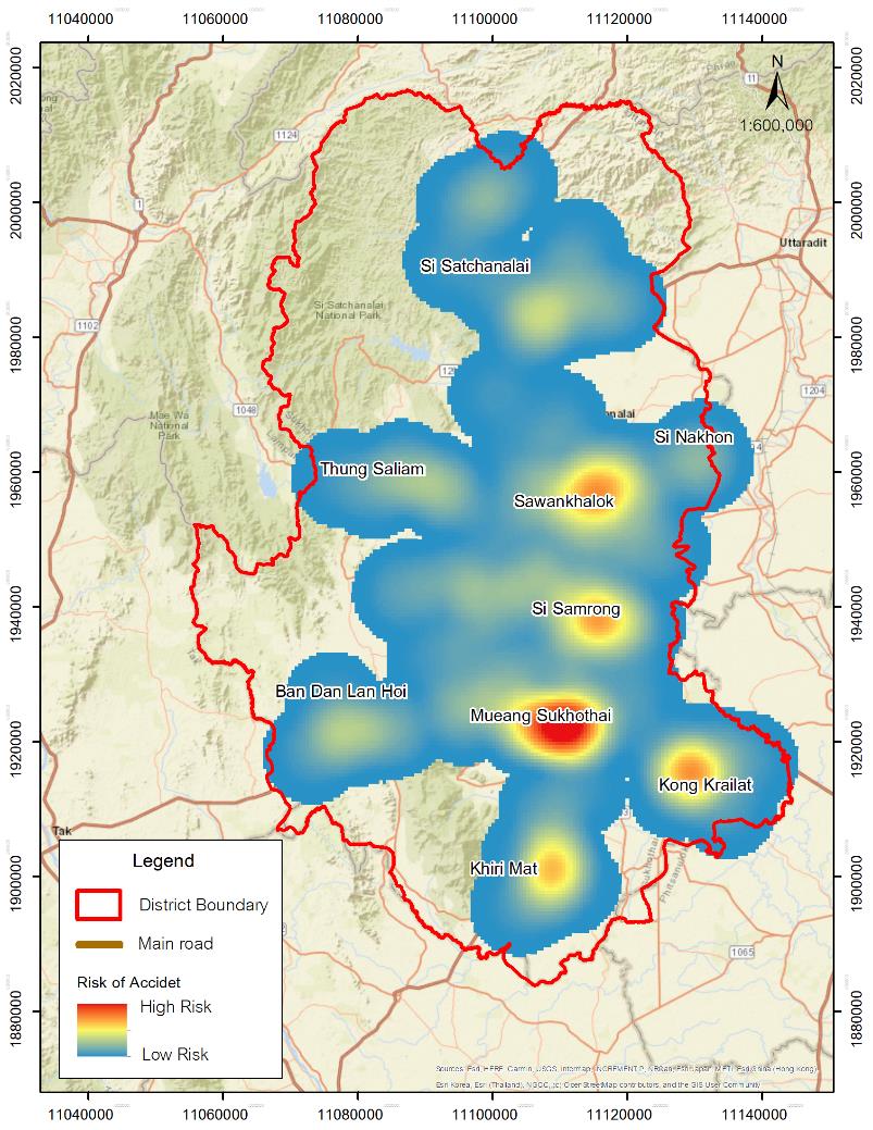
Figure 2: Sukhothai province, Thailand
4. Research Results
Sukhothai Province is located in the lower north and upper central
region of the country (Figure 2). There is a main road
which connects Phitsanulok Province, which is an Indochinese
intersection, to Tak Province. Travel to Sukhothai is convenient via
various modes. The Yom River flows through the city center. Sukhothai
covers an area of 4,112,577 rai or 6,596.092 square kilometers in
connection with the nearby provinces as follows:
North: Connect to Wang Chin District and Sung Men District in Phrae
Province; and Laplae District in Uttaradit Province.
South: Connect to Phran Kratai District in Kamphaeng Phet Province and
Bang Rakam District in Phitsanulok Province.
East: Connect to Phrom Phiram District in Phitsanulok Province, and
Phichai District in Uttaradit Province.
West: Connect to Mueang Tak District in Tak Province, and Thoen
District in Lampang Province.
Regarding the accident sites, there were 217 accident sites involving
motorcycles and high school students in the 2019 fiscal year in the
areas of Sukhothai Province. The GIS data layer of the accident sites
was created with attribute data of dates, months, time, party 1, party
2, party 3, accident aspects, route aspects, accident positions, roads,
injuries, deaths, and location coordinates of traffic accidents. This
means the data about accidents, the number of accident sites involving
motorcycles and high school students in the 2019 fiscal year in the
areas of Sukhothai Province, which were analyzed by GIS in combination
with KDE and NKDEX by using the KDE and NKDE methods, a map of traffic
accident density was created to display the distribution of traffic
accidents in 9 districts, as shown in Figure 3. In the
site analysis of traffic accidents by using the GIS with KDE and NKDE,
the density map displayed the traffic accident density in three
districts: 1) Mueang, 2) Si Samrong, and 3) Sawankhalok. The description
of each district is presented below.
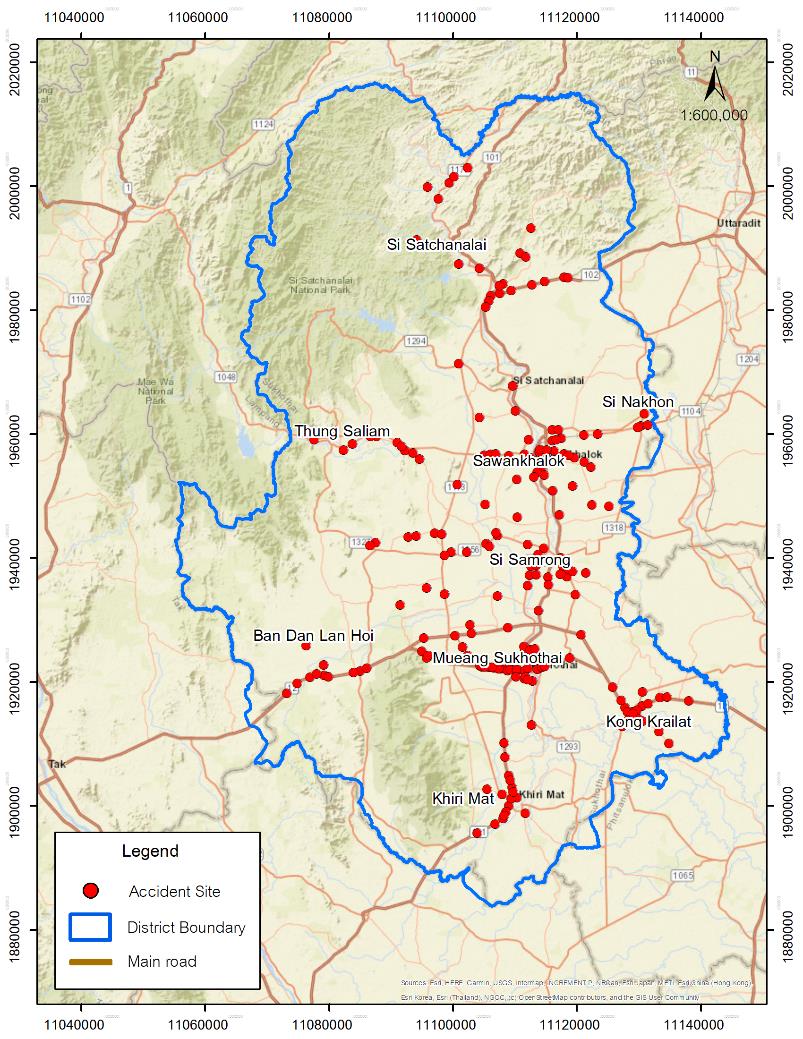
Figure 3: The overview of accident sites involving
motorcycles among high school students in 9 districts of Sukhothai
Province in 2019
4.1 Mueang District
The areas with a high density of traffic accidents were Khong In-Si
Intersection, the intersection in front of Sukhothai Wittayakom School,
and Tri Rat Intersection, as shown in Figure 4.
4.1.1 Khong In-Si Intersectionis an intersection in the city
center with traffic jams in the morning and evening on both the inbound
and outbound routes as the main routes to Udomdarunee School, a park,
exercise yard, food market, and product markets, etc. In addition, there
are many workplaces in this area. Due to the lack of accident-warning
signs and traffic light, motorcycle crashes frequently occurred at the
intersection area. The main causes of accidents were rear-ending
collisions, pushing into a lane, and not giving way to others.
4.1.2 The intersection at the front of Sukhothai Wittayakom School
includes main roads for commuters as it is near the school and a
technical college. It has the route to Big C Supercenter and another
main route to Tak Province. Therefore, accidents often occurred in the
morning and evening rush hours.
4.1.3 Tri Rat Intersection is another risk point as it is a
T-junction to night food markets, the city center, and provincial hall.
People usually commute to buy things at the market, go to work, and eat
at the restaurants near this intersection. Therefore, motorcycle
accidents frequently occurred in this area. The main causes of
accidents were overtaking in the congested area and cutting-off other
road users. These accident sites are displayed with colors as shown in
Figure 5, while red to indicate repeated accidents in
the past 3 years, and yellow to indicate repeated accidents in the past
5 years.
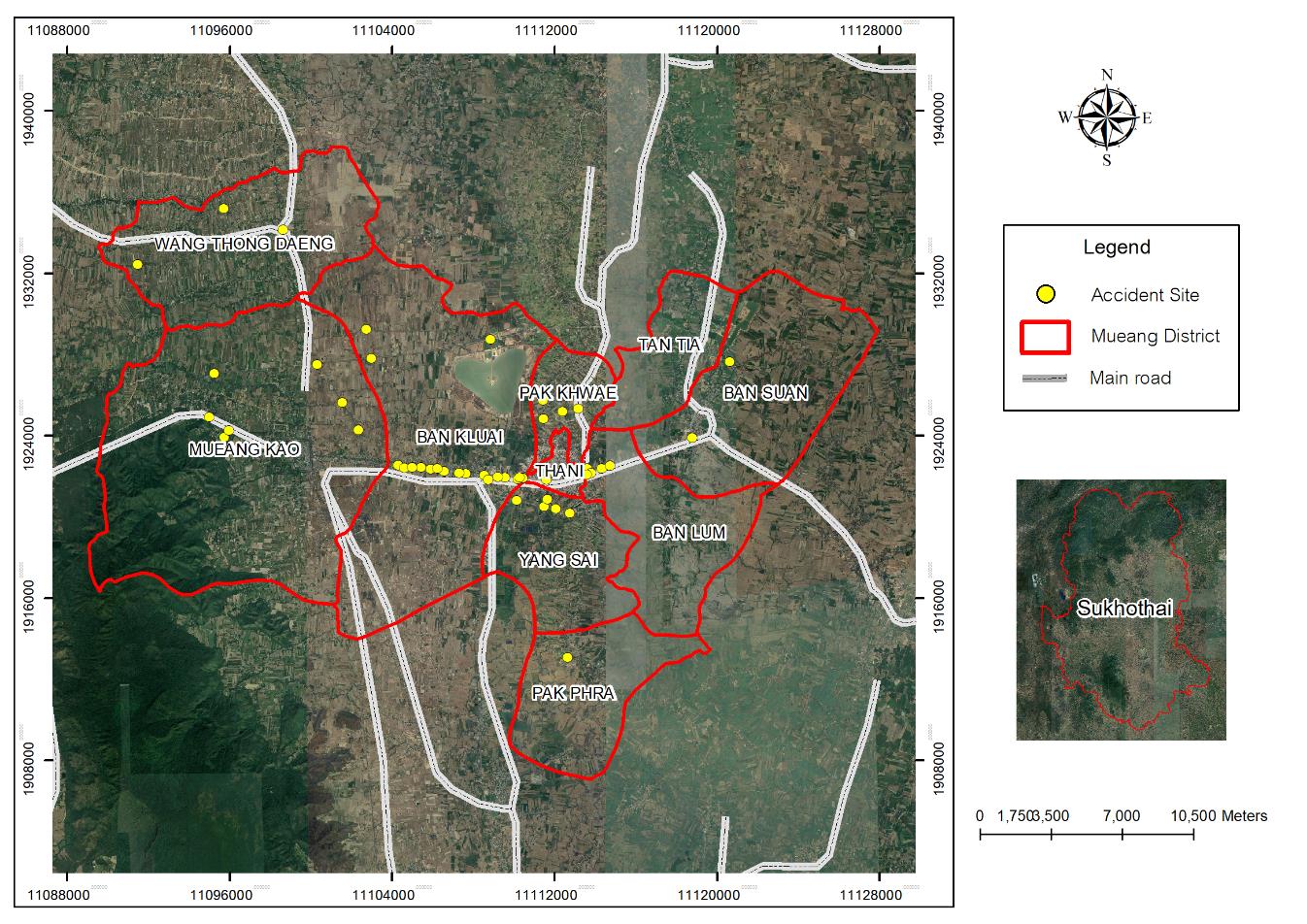
Figure 4: Density of traffic accidents involving
motorcycles and high school students in Mueang District, Sukhothai
Province in 2019
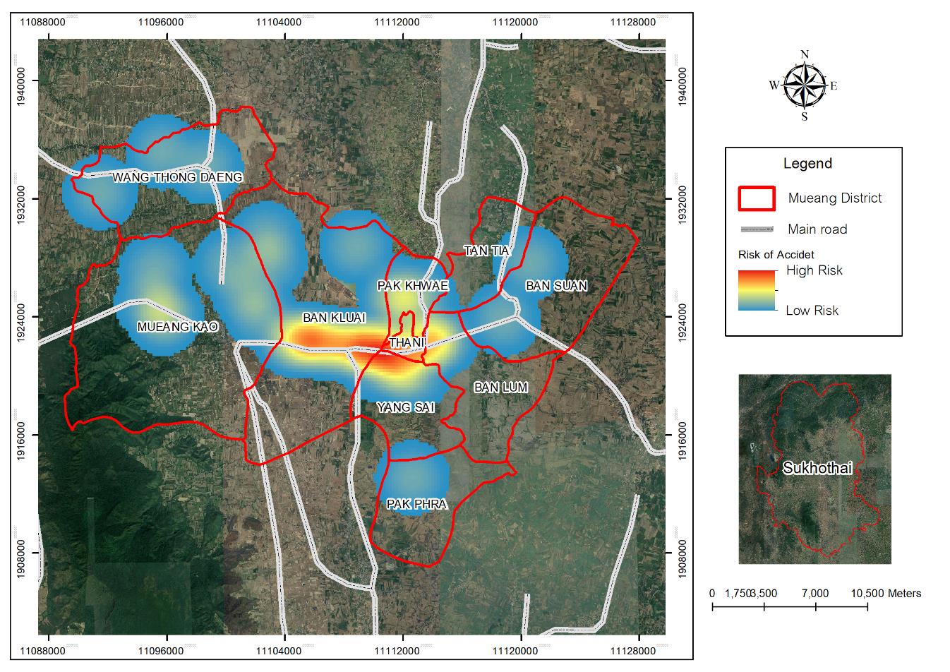
Figure 5: Repeated accident of traffic accidents
involving motorcycles and high school students in Mueang District,
Sukhothai Province in 2019
4.2 Si Samrong District
The areas with a high density of traffic accidents were the
intersection with traffic light at the back area, Wat Photharam
Intersection, and the shortcut route to Wang Luk Sub-district in
connection between Si Samrong and Mueang Sukhothai, as shown in
Figure 6.
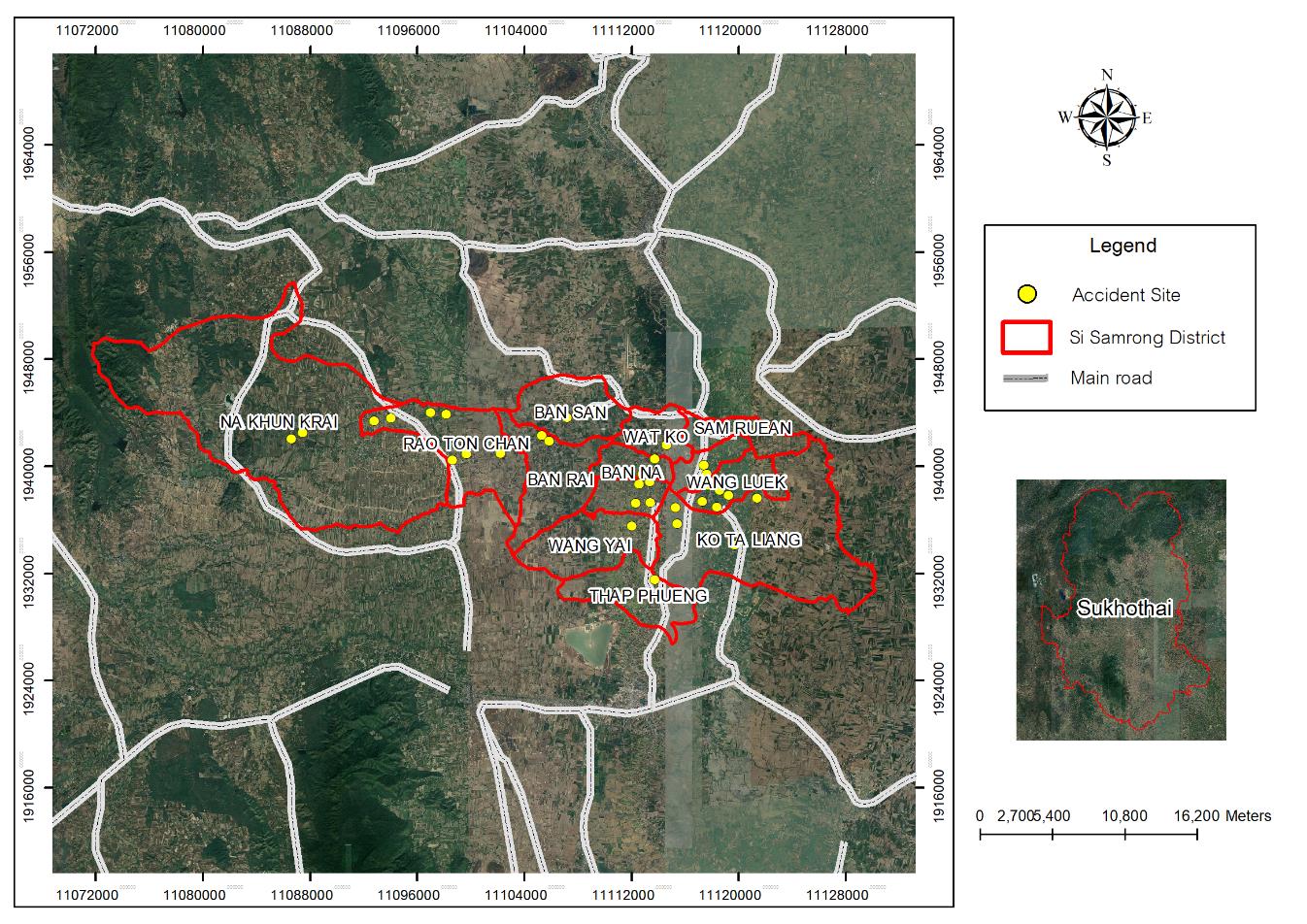
Figure 6: Density of traffic accidents involving
motorcycles and high school students in Si Samrong District, Sukhothai
Province in 2019
4.2.1 The intersection with traffic lights at the back area is
a 2-lane bypass from the main road connecting Mueang District and
Sawankhalok District. Vehicles frequently running on this road were
agricultural vehicles and motorcycles. Students were unaware of other
vehicles. The causes of accidents were fast riding, the narrow road,
and improperly maintained vehicles.
4.2.2 Wat Photharam intersection connects the main road to a
community road.
From the investigation, it was found that motorcycles ran on the 4-lane
main road in connection to the 2-lane road. The causes of accidents
were fast riding, rear-end collisions, and insufficient lighting.
4.2.3 The shortcut route to Wang Luk Sub-district connecting Si
Samrong and Mueang Sukhothai
is another route which high school students used after school. This
route connects to Phitsanulok Province. The causes of accidents were
fast riding, sudden turning, and a curved route without clear warning
signs. These accident sites are displayed with colors as shown in
Figure 7, while red to indicate repeated accidents in
the past 3 years, and yellow to indicate repeated accidents in the past
5 years.
4.3 Sawankhalok District
The areas with a high density of traffic accidents were Saphan Chan
Intersection, Chanthararophat Intersection, and Kai Yang Phikunthong
Intersection. According to the statistical analysis, it was found that
there were averagely 3 accidents/year at Saphan Chan Intersection, 2
accidents/year at Chanthararophat Intersection, and 3 accidents/year at
Kai Yang Phikunthong Intersection as shown in
Figure 8
.
4.3.1 Saphan Chan intersectionincludes 2-lane roads in
connection to Si Satchanalai District. In the morning and evening, it
is crowded with agricultural and student vehicles. The causes of
accidents were fast riding, damaged traffic signs, and narrow road
shoulders. There were 3 accidents/year.
4.3.2 Chanthararopat intersectionincludes 4-lane roads with
fast commuters as there are community areas and a flea market. The
traffic was heavy from afternoon to evening. The causes of accidents
were shoving sideways, cutting-off other vehicles, and sudden turning.
There were 2 accidents/year.
4.3.3 Kai Yang Phikunthong intersectionis a shortcut to the
back road. There is a petrol station and some convenience stores. The
causes of accidents were fast riding, cutting-off other vehicles,
sudden overtaking, and unclear warning signs. There were 2
accidents/year. These accident sites are displayed with colors as shown
in Figure 9, while red to indicate repeated accidents
in the past 3 years and yellow to indicate repeated accidents in the
past 5 years.
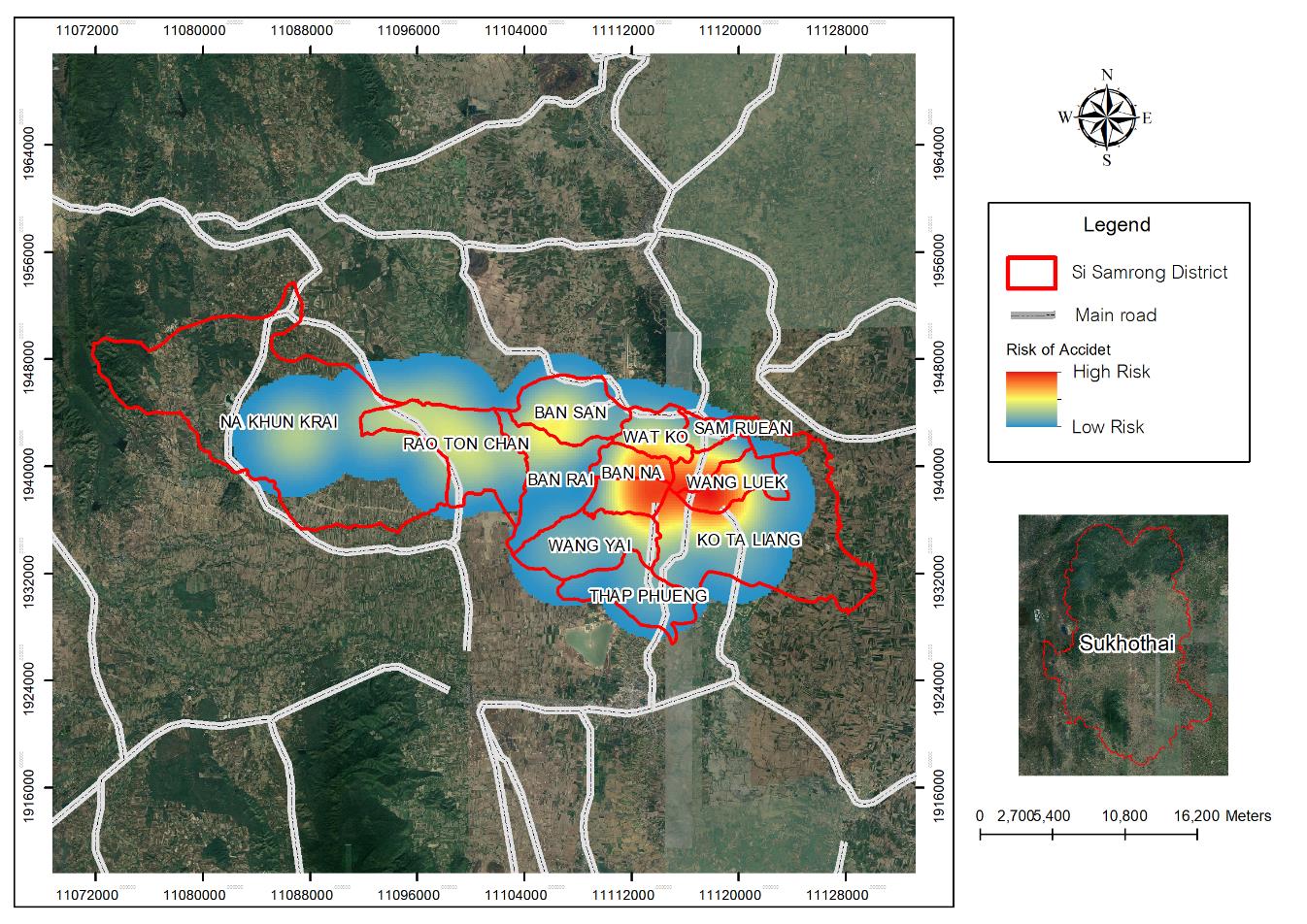
Figure 7: Repeated accident of traffic accidents
involving motorcycles and high school students in Si Samrong District,
Sukhothai Province in 2019

Figure 8: Density of traffic accidents involving
motorcycles and high school students in Sawankhalok District, Sukhothai
Province in 2019

Figure 9: Repeated accident
of traffic accidents involving motorcycles and high school students in
Sawankhalok District, Sukhothai Province in 2019
5. Conclusion
The Geographic Information System (GIS) is suitable for collecting the
data of traffic accidents and other relevant data for planning to reduce
the risks of traffic accidents in the future. Such feedback provides
empirical evidence which is useful in utilizing communication technology to
raise awareness of the need to monitor risk points to prevent damage from
road accidents. The new findings in this study were: 1) the application of
communication technology makes the data reliable to create empirical
evidence which can be conveniently used for the data analysis; 2) planning
with authentic data enables a better problem-solving approach, and 3)
solving traffic-accident problems requires data and participation from all
sectors. Additional analysis and supporting details are as follows:
1. The geographic information system (GIS) is useful because it can provide
clear pictures at the accident sites. These pictures can raise people’s
awareness of caution at the accident sites and dangerous roads in order to
plan preventive measures.
2. GIS information can be used for planning accident prevention at the
regular points. According to the data collected for 1 year, there was no
repetitive accidents.
3. The GIS can create participation of all sectors. At every meeting
arranged by road safety centers, relevant agencies discuss about relevant
issues for collaboratively plan preventive measures with evidence of the
meeting minutes and monthly monitor of progress
One discovered knowledge is to have the perspective on the clearer
problem-solving. The in-depth interview during the site visit makes it
clear that the clear specification of the site helps to prevent the
reoccurrence of road accident and set the preventive measure for the nearby
risky locations to minimize the road accident.
Discussion: To solve road accident problems requires collaboration from all
sectors and power of data which must be true, accurate, valid, and
verifiable. The GIS system can support such issues.
Findings and Discussion
According to the analysis of traffic accidents and the additional fieldwork
survey, it can be concluded that most accidents in the Sukhothai area
occurred at intersections or junctions
[10],
and on main roads. The intersections or junctions included Khong In-Si
Intersection, Saphan Chan Intersection, Tri Rat Intersection, and the
intersection at the night food market. The causes of accidents at these
sites were analyzed and it was found that the causes were careless, fast
riding, immediate cutting-off other road users, narrow road shoulders, and
non-compliance to traffic regulations. The study of Hisam et al.,[11] found that accidents in Malaysia often occurred in the afternoon at
intersections.
The accident sites on the main roads were Highway 12 connecting
Phitsanulok, Sukhothai, and Tak Provinces while other accident sites were
the secondary roads to Sawankhalok, Uttaradit, and Mueang Sukhothai. The
main causes of motorcycle accidents among high school students in the areas
were overtaking, cutting-off other vehicles, careless riding, violation of
traffic lights, and non-compliance with traffic regulations. The supporting
factors of accidents were engineering design in designing roads, road
conditions, the number of lanes, intersections with crossing traffic flows
such as intersections near bridge entrances and exits, or large
intersections etc. Surroundings are another important factor, especially in
the lack of traffic signs, rough road surfaces, and poor visibility.
Moreover, some external controllable factors were the construction of
buildings or roads. The causes of traffic accidents in the urban areas were
from daily riding behaviors, analyzed from the in-depth interview and
hospital history inquiry. The causes of accidents were found 73% from fast
riding, 27% from alcohol drinking, and 91% from not wearing a safety
helmet. Traffic density [12] was different from the rural areas where the
main causes of accidents were from fast riding and drunk riding.
The findings of this study are consistent with the findings in the study of
Konkeaw et al., [13] which analyzed the density of traffic accidents by
using GIS in Nai Mueang Sub-district, Mueang District, Kamphaeng Phet
Province. Another study by Ruthirako et al., [14]
applied GIS to identify accident sites in Kho Hong Municipality, Hat Yai
District, Songkhla Province, whereas the study of Pimsang [15] analyzed Quantum GIS to find the density of land traffic accidents at
Naresuan University and the surrounding areas. Moreover, the study of
Wongho [16] used the data to determine spatial factors expected to have
effects on accidents by dividing areas into grids and calculating means of
variables in order to find the relationships with accidents in Phitsanulok
Province by using linear regression analysis for the statistical analysis.
According to the analysis, it was found that traffic congestion was the
probable cause of accidents occurring during the rush hours from 7 am – 9
am and 3.30 pm – 6.00 pm as these were the travel periods when students
went to/from school and people went to/from work. To solve this problem,
traffic police officers are required to regulate traffic at different
intersections and risk points.
Benefits of the Study
The study results are useful for planning to reduce road accidents
involving motorcycles by improving possible risk points. The results can
also be used as empirical data for running campaigns to reduce traffic
accidents such as by setting community checkpoints, fixing warning signs,
and building participation to prevent traffic accidents in order to reduce
the loss of high school students who are the nation’s future.
Suggestions
Suggestions for applying the study results
1. Relevant agencies can use the study results to manage traffic accidents
in their own areas. These agencies include provincial police stations,
provincial education authorities, teachers and schools, Sukhothai Highways,
Office of Disaster Prevention and Mitigation Sukhothai Municipality, and
road safety centres at the provincial and district levels. These agencies
can apply the study results to support spatial management of traffic
accidents and risk reduction of traffic accidents.
2. Relevant agencies such as local government administrations can use the
map of traffic accident density for sharing knowledge with communities to
reduce traffic accidents and support safe riding/driving in those areas.
Suggestions for Future Research
1. Spatial data of traffic accidents should be collected continuously for
analysis to find causes, provide warning, conduct surveillance, and prevent
traffic accidents, and to reduce risk effectively.
2. Traffic accidents outside the urban areas should be studied to identify
risk points and to compare risk aspects, leading to effective management of
urban and non-urban traffic accidents.
References
[1] World Health Organization, (2018).
World Health Statistics 2018: Monitoring Health for the SDGs,
Sustainable Development Goals . Geneva: World Health Organization.
[2] Wittangkul C., (2020).
Thai Road Accidents in a Foreign Perspective 2020
[Online]. Available:
https://www.bangkokbiznews.com/blog/detail/650575.
[Accessed Apr. 30, 2020].
[3] Sontikul, S., (2016).
Motorcycle Related Injuries in Children in the South-East Asia Region
. Nonthaburi: Thai Health Promotion Foundation.
[4] Office of Transport and Traffic Policy and
Planning, (2019). Traffic Accident Situation Report[Online].
Available:
https://www.otp.go.th/uploads/tiny_uploads/PDF/2563-06/25630601-Road .
[Accessed Aug. 30, 2019].
[5] World Health Organization, (2018).
Global Status Report on Road Traffic Injury 2018
[Online]. Available:
https://www.who.int/violence_injury_prevention/road_safety_status/2018/en/[Accessed Jul. 7, 2018].
[6] Security Academic Center, (2018).
Global Road Safety Situation Report
. Bangkok: Safety Academic Center.
[7] Sukhothai Provincial Public Health Office,
(2018). Road Accident Situation Report 2018. Sukhothai: Sukhothai
Provincial Public Health Office.
[8] Kingkaew K., (2019).
Sukhothai Meeting of the Center for Preventing and Reducing Road
Accidents during the New Year Festival
[Online]. Available:
https://thainews.prd.go.th/th/news/detail/TCATG181230113255030.
[Accessed May 10, 2019].
[9] Investigation work at the Sukhothai Provincial
Police Station, (2019).
Objectives of training Mueang Sukhothai Police Station
. Sukhothai: Investigation work at the Sukhothai Provincial Police Station.
[10] Sukhothai Provincial Public Health Office,
(2019).
Traffic Injury Report from Chronic Non-Communicable Diseases Sukhothai
Provincial Public Health Office
. Sukhothai: Sukhothai Provincial Public Health Office.
[11] Hisam, F., Halim, M., Naharudin, N. and
Hashim, N., (2022). GIS Analysis on Road Accident and Road Safety: A Case
Study of Road Geometry in Kajang, Selangor.
International Journal of Geoinformatics,
Vol.18(4), 45-50.
https://doi.org/10.52939/ijg.v18i4.2257.
[12] Wandani, F. P., Siti, M., Yamamoto, M. and Yoshida, Y., (2018).
Spatial Econometric Analysis of Automobile and Motorcycle Traffic on
Indonesian National Roads and its Socio-Economic Determinants: Is it Local
or Beyond City Boundaries?. IATSS Research,Vol.42(2),76-85.
< a href="https://doi.org/10.1016/j.iatssr.2017.07.001">
https://doi.org/10.1016/j.iatssr.2017.07.001.
[13] Konkeaw, C., Souataisong, A., Chinda-in S. and
Ruthamnong S., (2021). Analysis of Traffic Accidents Density Using
Geographic Information System, Nai Mueang Subdistrict, Mueang Kamphaeng
Phet District, Kamphaeng Phet Province.
The 1st Kamphaeng Phet Rajabhat University Student National Conference
, Kamphaeng Phet Rajabhat University, 586-594.
[14] Ruthirako, P., Manwicha. J. and Chukuan, P.,
(2016). Application of Geographic information Systems for Identify Traffic.
The 7th Hatyai National and International Conference, Songkhla:
Hatyai University, 1366-1376.
[15] Pimsang, P., (2020).
Traffic Accident Problems in Naresuan University and Surrounding Areas.
Master Thesis, Faculty of Agriculture, Natural Resources and Environment
Naresuan University, Phitsanulok.
[16] Wongho, L., (2017).
Analysis of Spatial Factors Affecting to Road Accident: A Case Study of
Muang District, Phitsanulok,
Bachelor's Thesis, Naresuan University, Phitsanulok.
